50% Off All Framed Art, Photography and Prints at FramedArt.com My Framed Photos
Save 5% More...

Traditional Maps

Categories:
  • Filter Your Art:
  • Print / Canvas / Frame
  • Subject
  • Size / Color / Shape
  • Sets
Sort By:
200 Items
Framed Mercator's World Map, 1524
Mercator's World Map, 1524
by Gerardus Mercator
12" x 8" Print
+ More Sizes
Price: $15.29 
Framed Terra Major Petites A
Terra Major Petites A
by Gerardus Mercator
12" x 12" Print
+ More Sizes
Price: $20.69 
Framed Terra Major Petites B
Terra Major Petites B
by Gerardus Mercator
12" x 12" Print
+ More Sizes
Price: $20.69 
Framed 1698 Louis Hennepin Map of North America
1698 Louis Hennepin Map of North America
 
14" x 12" Print
+ More Sizes
Price: $23.39 
Framed 1856 Mitchell Wall Map of the United States and North America
1856 Mitchell Wall Map of the United States and North America
 
12" x 12" Print
+ More Sizes
Price: $20.69 
Framed 1795 D'Anville Wall Map of South America
1795 D'Anville Wall Map of South America
 
14" x 12" Print
+ More Sizes
Price: $22.49 
Framed 1776 Zatta Map of California and the Western Parts of North America
1776 Zatta Map of California and the Western Parts of North America
 
15" x 12" Print
+ More Sizes
Price: $24.29 
Framed 1900 U.S. Geological Survey Map of Provincetown, Cape Cod, Massachusetts 1900
1900 U.S. Geological Survey Map of Provincetown, Cape Cod, Massachusetts 1900
 
9" x 12" Print
+ More Sizes
Price: $17.99 
Framed 1908 U.S. Geological Survey Map of Provincetown, Cape Cod, Massachusetts1908
1908 U.S. Geological Survey Map of Provincetown, Cape Cod, Massachusetts1908
 
11" x 8" Print
+ More Sizes
Price: $15.29 
Framed 1940 Colonial Craftsman Decorative Map of Cape Cod, Massachusetts
1940 Colonial Craftsman Decorative Map of Cape Cod, Massachusetts
 
11" x 8" Print
+ More Sizes
Price: $15.29 
Framed Canal du Cape-Cod Massachusetts, 1834 map
Canal du Cape-Cod Massachusetts, 1834 map
 
11" x 8" Print
+ More Sizes
Price: $15.29 
Framed 1864 Mitchell Map of Washington D.C.
1864 Mitchell Map of Washington D.C.
 
11" x 8" Print
+ More Sizes
Price: $15.29 
Framed 1864 Johnson Map of Washington D.C. and Georgetown
1864 Johnson Map of Washington D.C. and Georgetown
 
11" x 8" Print
+ More Sizes
Price: $15.29 
Framed 1930 Pictorial Map of North America and South America
1930 Pictorial Map of North America and South America
 
9" x 12" Print
+ More Sizes
Price: $17.99 
Framed Americae nova Tabula - Map of North and South America
Americae nova Tabula - Map of North and South America
 
11" x 8" Print
+ More Sizes
Price: $15.29 
Framed Claude Bernou Carte de lAmerique septentrionale
Claude Bernou Carte de lAmerique septentrionale
 
11" x 8" Print
+ More Sizes
Price: $15.29 
Framed John Lord Sommers Map of North America
John Lord Sommers Map of North America
 
11" x 8" Print
+ More Sizes
Price: $15.29 
Framed Nord-Amerika Politisk Ofversiktskarta, Nordisk familjebok
Nord-Amerika Politisk Ofversiktskarta, Nordisk familjebok
 
9" x 12" Print
+ More Sizes
Price: $17.99 
Framed 1852 Bocage Map of North America
1852 Bocage Map of North America
 
9" x 12" Print
+ More Sizes
Price: $17.99 
Framed 1856 Mitchell Wall Map of the United States and North America
1856 Mitchell Wall Map of the United States and North America
 
11" x 8" Print
+ More Sizes
Price: $15.29 
Framed 1857 Dufour Map of North America
1857 Dufour Map of North America
 
9" x 12" Print
+ More Sizes
Price: $17.99 
Framed 1862 Johnson Map of North America
1862 Johnson Map of North America
 
9" x 12" Print
+ More Sizes
Price: $17.99 
Framed 1864 Mitchell Map of North America
1864 Mitchell Map of North America
 
9" x 12" Print
+ More Sizes
Price: $17.99 
Framed 1866 Johnson Map of Central America
1866 Johnson Map of Central America
 
11" x 8" Print
+ More Sizes
Price: $15.29 
Framed 1747 Bowen Map of North America and South America
1747 Bowen Map of North America and South America
 
11" x 8" Print
+ More Sizes
Price: $15.29 
Framed 1788 Schraembl - Pownall Map of North America the West Indies
1788 Schraembl - Pownall Map of North America the West Indies
 
11" x 8" Print
+ More Sizes
Price: $15.29 
Framed 1806 Cary Map of the Western Hemisphere
1806 Cary Map of the Western Hemisphere
 
11" x 8" Print
+ More Sizes
Price: $15.29 
Framed 1818 Pinkerton Map of British North America
1818 Pinkerton Map of British North America
 
11" x 8" Print
+ More Sizes
Price: $15.29 
Framed 1818 Pinkerton Map of North America
1818 Pinkerton Map of North America
 
11" x 8" Print
+ More Sizes
Price: $15.29 
Framed 1827 Finley Map of North America
1827 Finley Map of North America
 
9" x 12" Print
+ More Sizes
Price: $17.99 
Framed 1855 Colton Map of North America
1855 Colton Map of North America
 
9" x 12" Print
+ More Sizes
Price: $17.99 
Framed 1658 Visscher Map of North America and South America
1658 Visscher Map of North America and South America
 
11" x 8" Print
+ More Sizes
Price: $15.29 
Framed 1698 Louis Hennepin Map of North America
1698 Louis Hennepin Map of North America
 
11" x 8" Print
+ More Sizes
Price: $15.29 
Framed 1720 Chatelain Map of North America
1720 Chatelain Map of North America
 
11" x 8" Print
+ More Sizes
Price: $15.29 
Framed 1747 Bowen Map of North America
1747 Bowen Map of North America
 
15" x 12" Print
+ More Sizes
Price: $24.29 
Framed 1873 U.S. Coast Survey Chart NJ and the Delaware Bay
1873 U.S. Coast Survey Chart NJ and the Delaware Bay
 
9" x 12" Print
+ More Sizes
Price: $17.99 
Sort By:
200 Items

Save More with Wall Sets

Framed 'Old World 2 Piece Art Print Set' border= 'Old World 2 Piece Art Print Set' 
by Posters International Studio  
Price: $59.99
Sale: $53.99
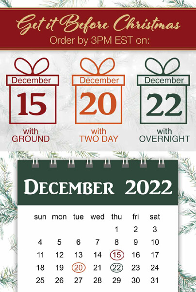
Holiday Shipping times